If you like snow then you will like this gallery of
photos. The Midwest Snow and Ice Storm of November 30th and December 1st, 2006 was one of the
better snow events I have experienced. It ranks in the top 10. To
view photographs just click on the image.
Blowing and drifting snow was severe in Downtown Peoria with drifts exceeding
four feet on some streets. Much of Central Illinois was shut down by this
storm. Some schools that had not been shut in 20+ years had to close
because of the heavy snow and ice accumulations.
Some of the photos at the top were taken during the evening of November 30th.
The main snowfall was between 4 a.m. and 10 a.m. on December 1st.
Visibility at times was less than one city block.
Pretty impressive for an early season snow event.
Thundersleet fell during the overnight hours of November 30th. Hail was
noted on several occasions with the sleet. Hailstones were between 0.25"
and 0.35" in size.
Thundersnow was also reported across portions of Central Illinois.
You can read the complete analysis of this storm and view weather maps, radar
images, and satellite data on the Winter Storm
Analysis Page.
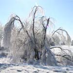
Ice storm photos can be viewed in Gallery 2. Unfortunately I did spend
enough time on covering that aspect of the stormy system. The photos are
not the best. I regret not stopping and spending some more time on that
facet of the storm. It took seven hours to return home.